Perry-Castañeda Library
Map Collection
Libya Maps
The following maps were produced by the U.S. Central Intelligence Agency, unless otherwise indicated.
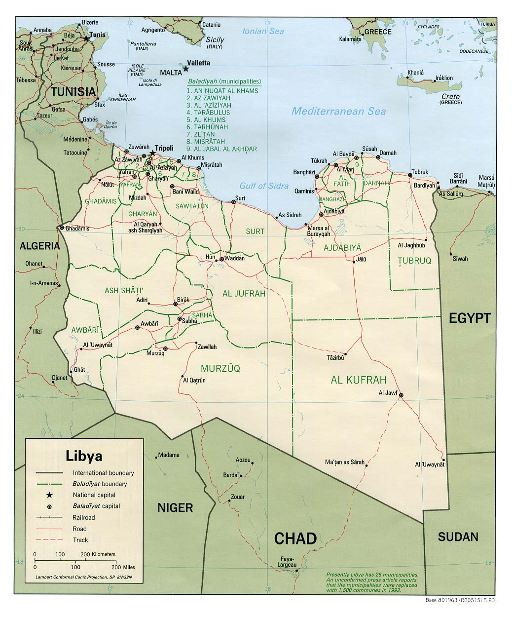
Country Maps- Libya (Political) 1993 (193K) and pdf format (203K)
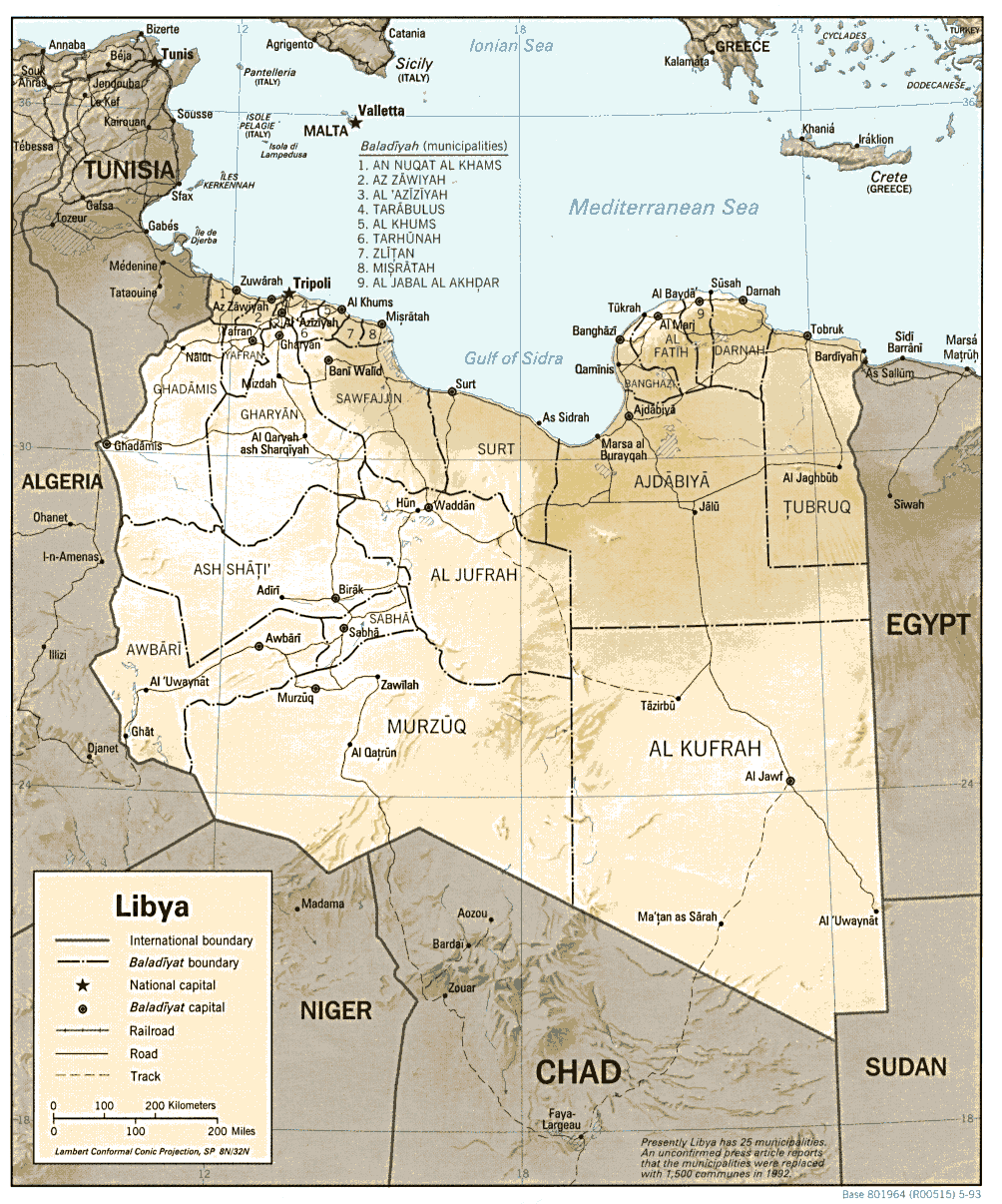
- Libya (Shaded Relief) 1993 (250K) and pdf format (263K)
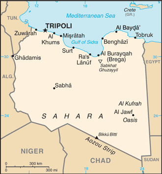
- Libya (Small Map) 2016 (11.9K)
- 1:2,000,000 - Africa Topographic Maps (U.S. Army Topographic Command/U.S. Defense Mapping Agency)
- This series covers all of Libya
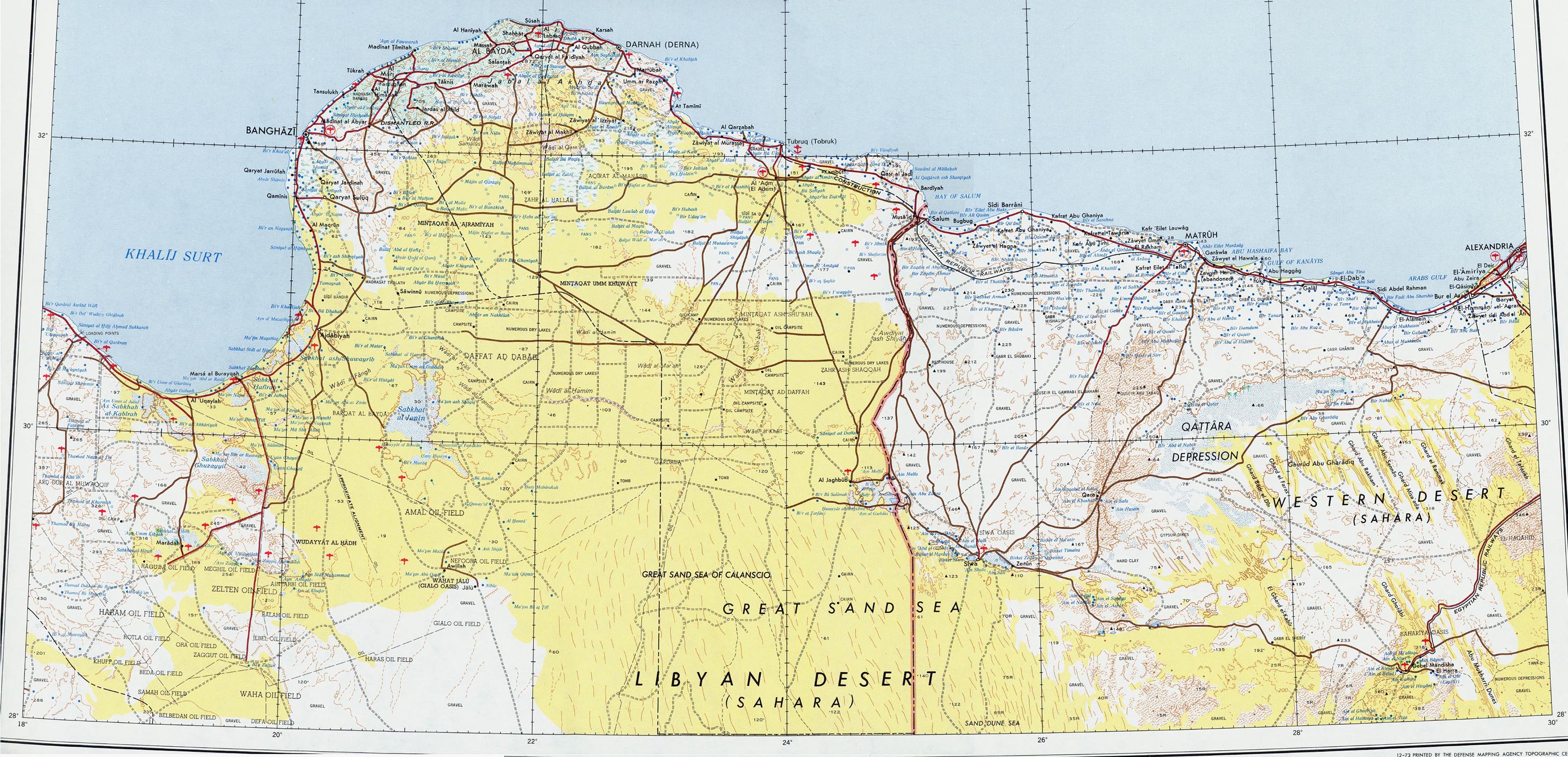
- 1:2,000,000 - Northeast Libya 1969 (1.12MB) and map key and scale (401K)
- Portion of AMS Series 2201, Sheet 4 "Banghazi" original scale 1:2,000,000. Published by the U.S. Army Map Service, 1973
- 1:1,000,000 - International Map of the World (U.S. Army Map Service)
- This series covers most of northern and central Libya
- 1:1,000,000 - Operational Navigation Chart Series U.S. Defense Mapping Agency Aerospace Center. Not for navigational use
- This series covers all of Libya
- 1:500,000 - French North Africa Series 4175, Great Britain War Office, 1941
- This series covers parts of Libya
- 1:500,000 - Tactical Pilotage Charts U.S. National Imagery and Mapping Agency. Not for navigational use
- This series covers Libya
- This series covers all of Libya
- 1:500,000 - Libya Series P461 (GSGS 4231), U.S. Army Map Service, 1941
- This series covers Libya
- 1:500,000 - World Series 1404, Great Britain. War Office and Air Ministry. 1958-
- This series includes a few parts of Libya along the Eastern border
- 1:250,000 - North Africa Topographic Maps (U.S. Army Map Service) 1954-
- This series covers much of Northern Libya and some other parts of the country
- 1:250,000 - Libya Joint Operations Graphic Aeronautical charts. U.S. National Imagery and Mapping Agency. Not for navigational use
- This series covers most of Libya
- 1:100,000 - Cyrenaica (U.S. Army Map Service) 1940-
- This series covers the eastern coastal area
- 1:100,000 - Tripoli (U.S. Army Map Service) 1936-
- This series covers the western coastal area and Tunisia border
- 1:100,000 - Tripoli (U.S. Army Map Service) 1936-
- This series covers the western coastal area and Tunisia border
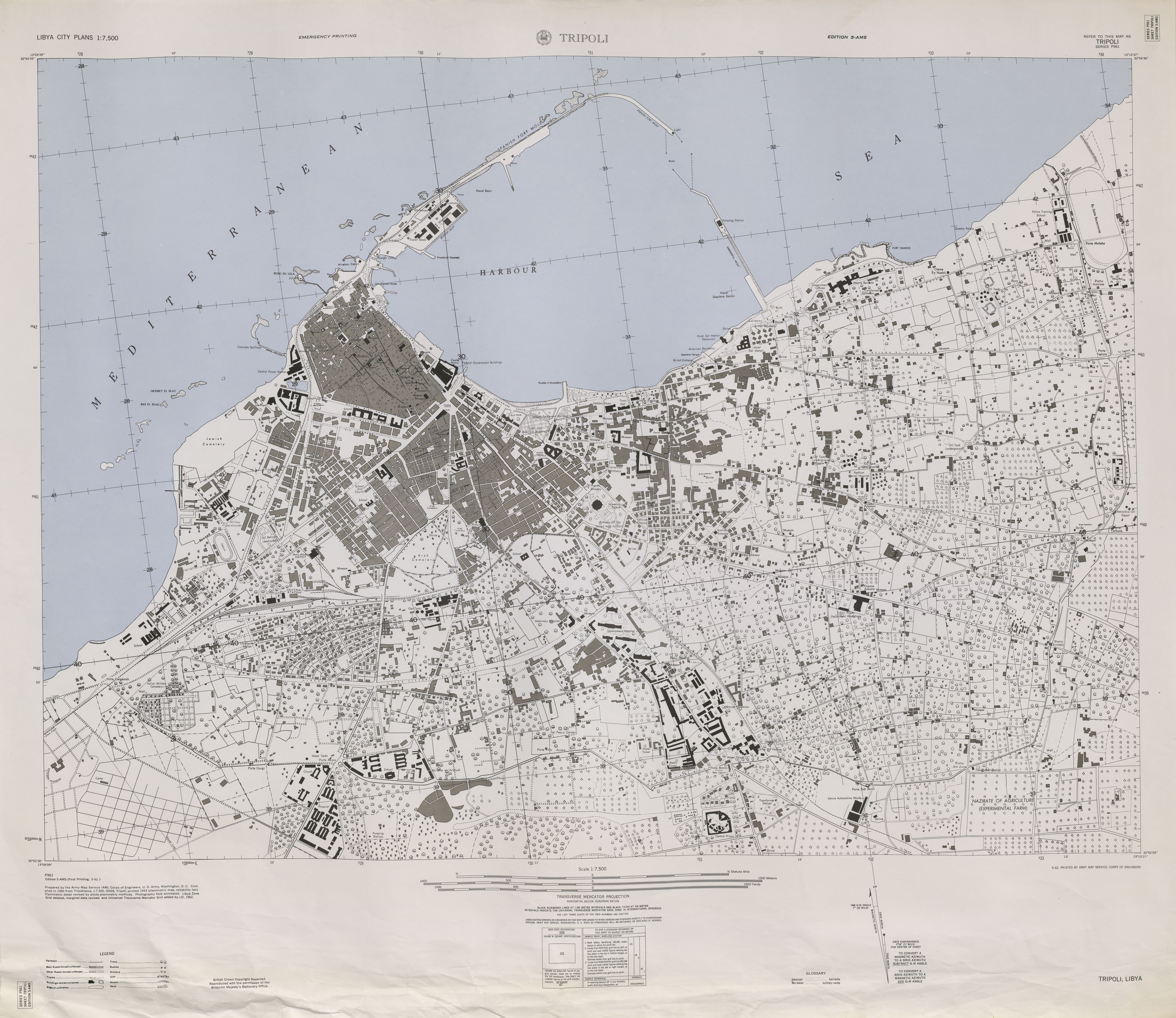
- 1:7,500 - Tripoli (U.S. Army Map Service) 1962 (3.0MB)
- This series covers all of Libya
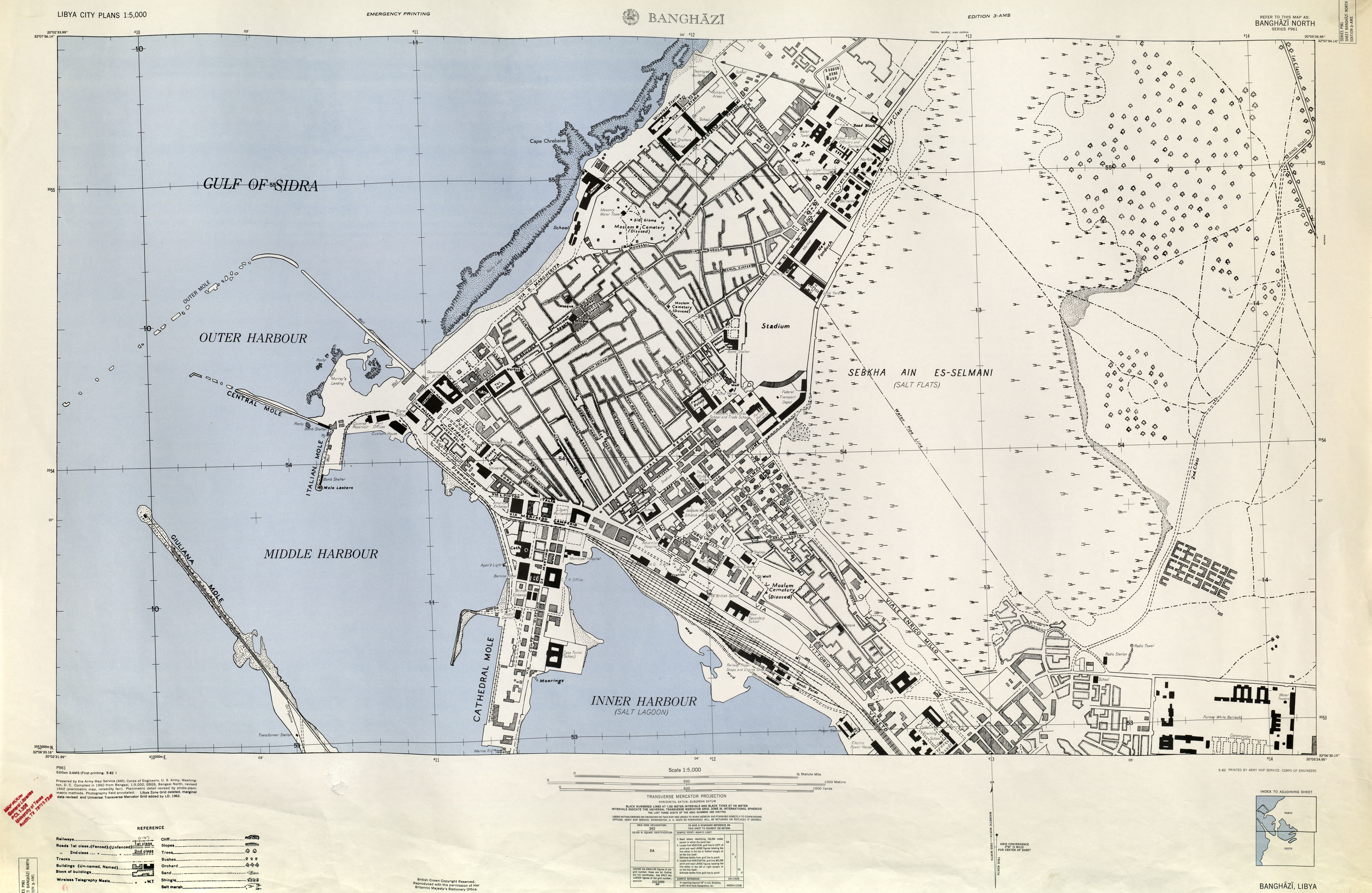
- Banghazi North 1:5,000, Edition 3-AMS, Series P961. U.S. Army Map Service, 1962 (4.3MB)
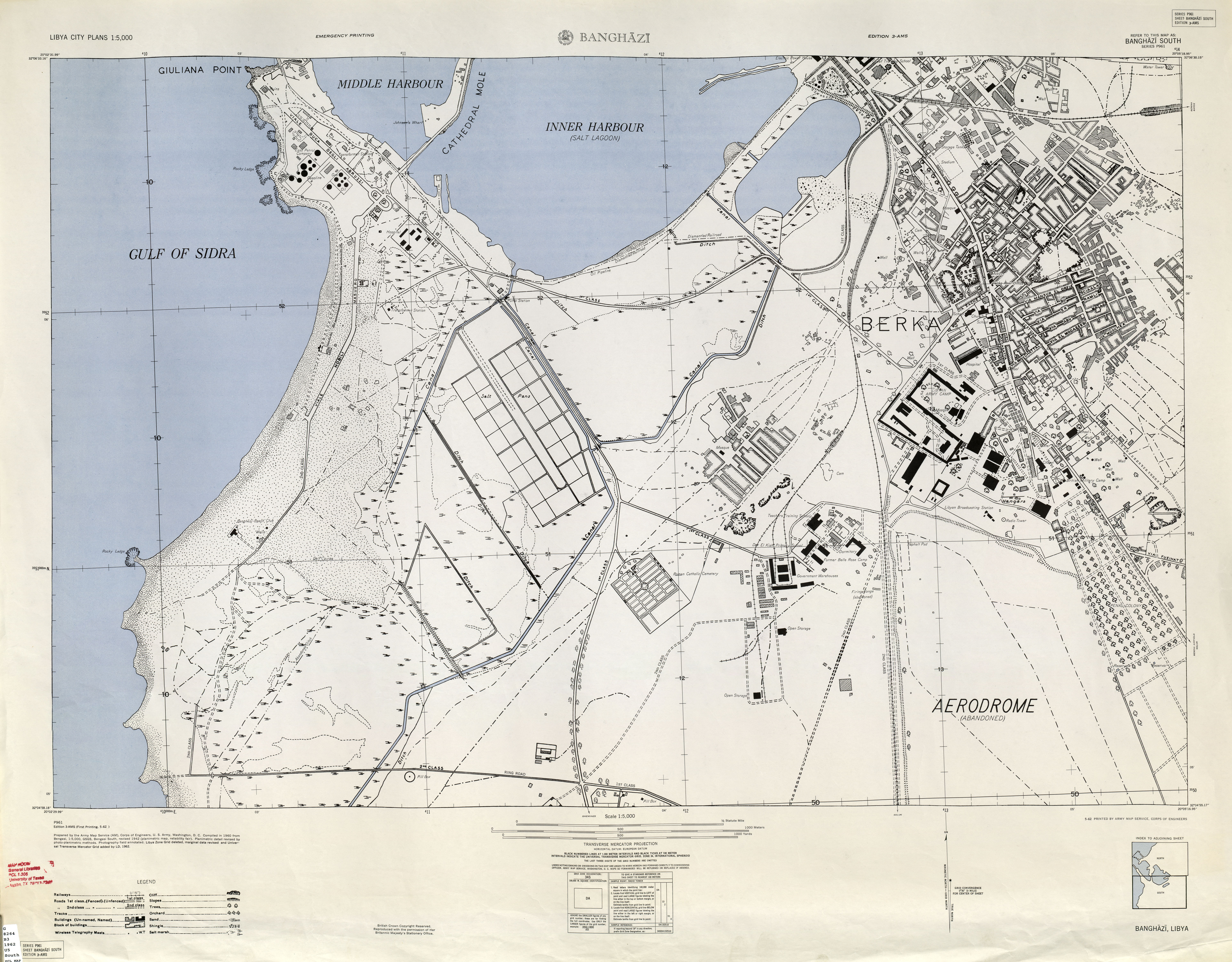
- Banghazi South 1:5,000, Edition 3-AMS, Series P961. U.S. Army Map Service, 1962 (5MB)
- Tripolitania (Libya) City Plans U.S. Army Map Service, 1943
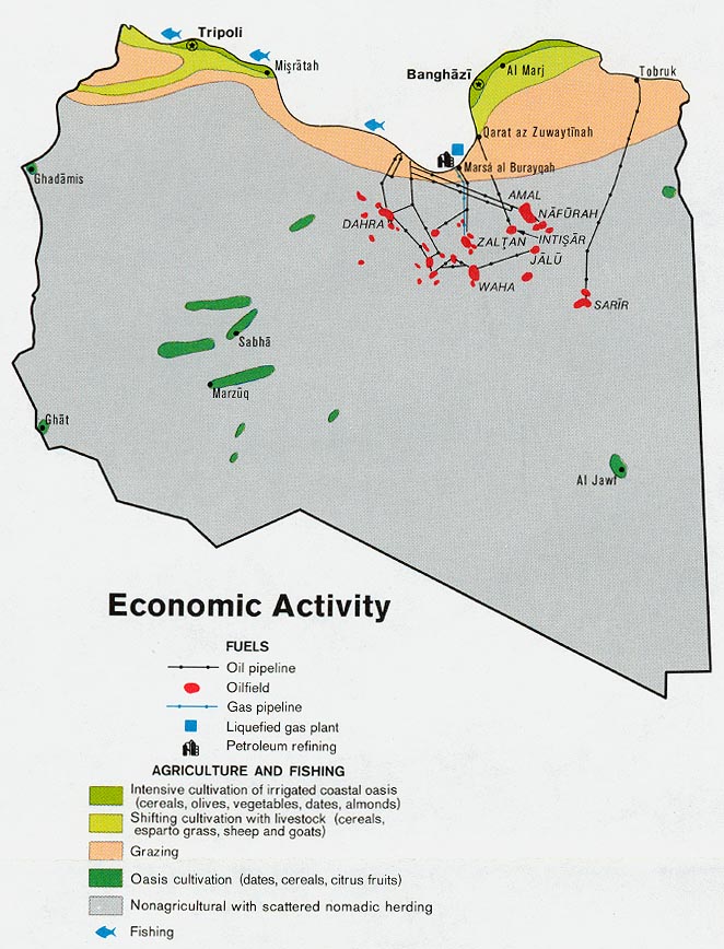
- Libya - Economic Activity from Map No. 501564 1974 (140K)
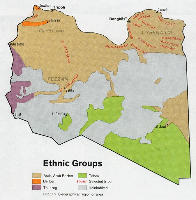
- Libya - Ethnic Groups from Map No. 501564 1974 (130K)
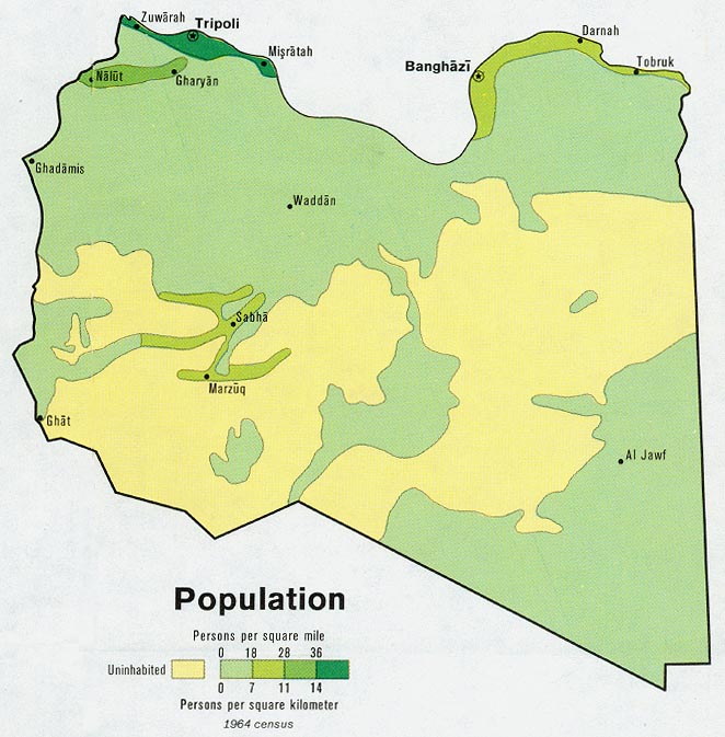
- Libya - Population from Map No. 501564 1974 (106K)
Maps on Other Web Sites
- Benghazi, Libya (LeadDog)
- Benghazi, Libya (UNOSAT)
- Benghazi Conflict Map [December 3, 2014] (Mutaz Gedalla)
- Benghazi Conflict Map [December 16, 2014] (Mutaz Gedalla)
- Tripoli, Libya (Google Maps)
- Tripoli, Libya (Libyana.org)
- Tripoli, Libya (LeadDog)
- Tripoli, Libya (UNOSAT)
- Libya Crisis Maps - 2011
- Libya - The Situation in Libya [November 6, 2014] (Thomas van Linge)
- Libya - The Situation in Libya [December 16, 2014] (Thomas van Linge)
- Libya - Situation [January 6, 2015] (JDD)
- Libya - Internal Displacement [March 2015] (IDMC)
- Libya - Groups in Control of Libya [March 3, 2015] (Middle East Eye)
- Libya - Oil and Gas Facilities [January 5, 2016] (AFP)
- Libya - The Situation in Libya [April 17, 2015] (Thomas van Linge)
- Libya - The Situation in Libya [June 15, 2015] (Thomas van Linge)
- Libya - Current Situation [2015-2016] (Libya Security Monitor)
- Libya - The Situation in Libya [January 4, 2016] (Thomas van Linge/IUCA)
- Libya - Military Situation [June 12, 2017] (Risk Intelligence)
- Libya - Military Situation [June 27, 2017] (Risk Intelligence)
- Libya - The Conflict in Libya [July 25, 2017] (AFP)
- Libya - Military Situation Map [August 7, 2017] (Risk Intelligence)
- Libya - Military Situation Map [August 29, 2017] (Risk Intelligence)
- Libya - Military Situation [October 2, 2017] (Risk Intelligence)
- Libya - Military Situation [October 9, 2017] (Risk Intelligence)
- Libya - Military Situation [April 3, 2018] (Risk Intelligence)
- Libya - Military Situation [April 29, 2019] (Risk Intelligence)
- Libya - Military Situation [April 30, 2018] (Risk Intelligence)
- Libya - Military Map South of Tripoli [May 4, 2019] (Islamic World News)
- Libya - Military Situation [June 10, 2019] (Risk Intelligence)
- Libya - Military Situation [July 8, 2019] (Risk Intelligence)
- Libya - Military Situation [July 26, 2019] (Risk Intelligence)
- Libya - Military Situation [August 19, 2019] (Risk Intelligence)
- Libya - Military Situation [September 2, 2019] (Risk Intelligence)
- Libya - Military Situation [September 16, 2019] (Risk Intelligence)
- Libya - Military Situation [November 25, 2019] (Risk Intelligence)
- Libya - Military Situation [December 9, 2019] (Risk Intelligence)
- Libya - Military Situation [January 20,2019] (Risk Intelligence)
- Libya - Military Situation [February 3, 2020] (Risk Intelligence)
- Libya - Military Situation [February 17, 2020] (Risk Intelligence)
- Libya - Military Situation [March 2, 2020] (Risk Intelligence)
- Libya - Military Situation [March 16, 2020] (Risk Intelligence)
- Libya - Military Situation [April 27, 2020] (Risk Intelligence)
- Libya - Military Situation [May 25, 2020] (Risk Intelligence)
- Libya - Military Situation [June 8, 2020] (Risk Intelligence
- Libya - Military Situation [July 6, 2020] (Risk Intelligence)
- Libya - Military Situation [August 17,2020] (Risk Intelligence)
- Libya - Military Situation [August 22, 2020] (Southfront.org)
- Libya - Military Situation [August 31, 2020] (Risk Intelligence)
- Libya - Military Situation [September 28, 2020] (Risk Intelligence)
- Libya - Military Situation [October 12, 2020] (Risk Intelligence)
- Libya Military Situation [November 23, 2020] (Risk Intelligence)
- Libya - Military Situation [December 7, 2020] (Risk Intelligence)
- Libya - Military Situation [January 18, 2021] (Risk Intelligence)
- Libya - Military Situation [March 29, 2020] (Risk Intelligence)
![Libya - The Situation in Libya [November 6, 2014] (Thomas van Linge)](http://i.imgur.com/kdnbHIo.png)
![Libya - The Situation in Libya [December 16, 2014] (Thomas van Linge)](http://i.imgur.com/kyhcrE0.png)
![Libya - The Situation in Libya [April 17, 2015] (Thomas van Linge)](https://pietervanostaeyen.files.wordpress.com/2015/04/2000px-libya2.png)
![Libya - The Situation in Libya [June 15, 2015] (Thomas van Linge)](https://pietervanostaeyen.files.wordpress.com/2015/06/2000px-libya3.png)
![Libya - Military Situation [June 12, 2017] (Risk Intelligence)](https://pbs.twimg.com/media/DCXQQ91W0AEA5oN.jpg:large)
![Libya - Military Situation [June 27, 2017] (Risk Intelligence)](https://pbs.twimg.com/media/DDVM4dAXsAAveXq.jpg:large)
![Libya - The Conflict in Libya [July 25, 2017] (AFP)](https://pbs.twimg.com/media/DFlARz8XgAAoSWs.jpg:large)
![Libya - Military Situation Map [August 7, 2017] (Risk Intelligence)](https://pbs.twimg.com/media/DG3u8W8XUAAJe6T.jpg:large)
![Libya - Military Situation Map [August 29, 2017] (Risk Intelligence)](https://pbs.twimg.com/media/DIe5C-tVAAIUOtV.jpg:large)
![Libya - Military Situation [October 2, 2017] (Risk Intelligence)](https://pbs.twimg.com/media/DLNywpBWsAAT9aM.jpg:large)
![Libya - Military Situation [October 9, 2017] (Risk Intelligence)](https://pbs.twimg.com/media/DLxGcesX0AAMEba.jpg:large)
![Libya - Military Situation [April 3, 2018] (Risk Intelligence)](https://pbs.twimg.com/media/DaV3jPoWkAAk6vC.png:large)
![Libya - Military Situation [April 29, 2019] (Risk Intelligence)](https://pbs.twimg.com/media/D5kRyZ-X4AYpdee.jpg:large)
![Libya - Military Situation [April 30, 2018] (Risk Intelligence)](https://pbs.twimg.com/media/DcRC3HPWkAAERHH.png:large)
![Libya - Military Situation [June 10, 2019] (Risk Intelligence)](https://pbs.twimg.com/media/D88EPFqXYAAt3n-.jpg:large)
![Libya - Military Situation [July 8, 2019] (Risk Intelligence)](https://pbs.twimg.com/media/D_roPuGWkAEqCqQ.jpg:large)
![Libya - Military Situation [July 26, 2019] (Risk Intelligence)](https://pbs.twimg.com/media/EAZAnCvXsAAakbf.jpg:large)
![Libya - Military Situation [August 19, 2019] (Risk Intelligence)](https://pbs.twimg.com/media/ECfuILqXYAAlH9H.jpg:large)
![Libya - Military Situation [September 2, 2019] (Risk Intelligence)](https://pbs.twimg.com/media/EDr9-THW4AAqpM9.jpg:large)
![Libya - Military Situation [September 16, 2019] (Risk Intelligence)](https://pbs.twimg.com/media/EFUBA_2W4AEg5lW.jpg:large)
![Libya - Military Situation [November 25, 2019] (Risk Intelligence)](https://pbs.twimg.com/media/ELB0OtPWkAIec9m.jpg:large)
![Libya - Military Situation [December 9, 2019] (Risk Intelligence)](https://pbs.twimg.com/media/ELqhpVTWoAAaxh1.jpg:large)